 show on map
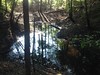

The location of this ore bank more-or-less matches the described location of the Conner Bank (see link below) though appears to have been worked extensively since the description was written. Other sources show Conner to be further southwest, but they show nothing at this location, so who knows...
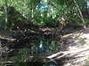
The mine consists of 3 large pits, all of which have become ephemeral ponds.
Someone hammered a section of light guage rail, vertically, into the ground in one of the pits. It's almost rusted through at the base, and may not stand for much longer.
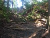
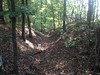
A long trench runs from south of the pits from near the road to a nearby dry creekbed. Its location suggests that its purpose was drainage. Maybe for an ore washer? Maybe water had to be pumped out of the pits regularly?
Historical topo maps show a pond across the road to the east, but I haven't explored that area yet.
A Preliminary Report on a Part of the Iron Ores of Georgia: Polk, Bartow and Floyd Counties, Issue 10 (Page 154)
Coords: 34.283850 N -84.726990 W
GPX Downloads: Waypoint