| at: |
Coleman River Scenic Area Trans North Georgia |
Data from David Muse
 show on map
 animate
Trail users:


Elevation Profile
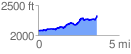
 3.665133 mi
 535.91 ft
 277.12 ft
 258.79 ft
 2.77 %
GPX Downloads: Track Route
![]()
| at: |
Coleman River Scenic Area Trans North Georgia |
show on map
animate
3.665133 mi
535.91 ft
277.12 ft
258.79 ft
2.77 %