|
| at: |
Coleman River Scenic Area Trans North Georgia |
Data from David Muse
 show on map
 animate
Trail users:


Elevation Profile
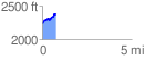
 0.767603 mi
 183.60 ft
 45.79 ft
 137.81 ft
 4.53 %
GPX Downloads: Track Route
![]()
|
| at: |
Coleman River Scenic Area Trans North Georgia |
show on map
animate
0.767603 mi
183.60 ft
45.79 ft
137.81 ft
4.53 %