|
| at: |
Coleman River Scenic Area |
Data from David Muse
 show on map
 animate
Trail users:


Elevation Profile
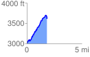
 1.843995 mi
 767.20 ft
 165.85 ft
 601.35 ft
 7.88 %
GPX Downloads: Track Route
![]()
|
| at: |
Coleman River Scenic Area |
show on map
animate
1.843995 mi
767.20 ft
165.85 ft
601.35 ft
7.88 %