|
| at: |
Coleman River Scenic Area |
Data from David Muse
 show on map
 animate
Trail users:


Elevation Profile
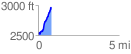
 0.815524 mi
 450.99 ft
 26.26 ft
 424.73 ft
 10.47 %
GPX Downloads: Track Route
![]()
|
| at: |
Coleman River Scenic Area |
show on map
animate
0.815524 mi
450.99 ft
26.26 ft
424.73 ft
10.47 %