| at: |
Coleman River Scenic Area |
Data from David Muse
 show on map
 animate
Trail users:


Elevation Profile
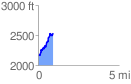
 0.941115 mi
 458.94 ft
 91.75 ft
 367.19 ft
 9.24 %
GPX Downloads: Track Route
![]()
| at: |
Coleman River Scenic Area |
show on map
animate
0.941115 mi
458.94 ft
91.75 ft
367.19 ft
9.24 %