| at: |
Tannehill Ironworks Historical State Park |
Data from Positive Flow
 show on map
 animate
Trail users:


Elevation Profile
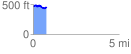
 0.791561 mi
 80.60 ft
 97.14 ft
 -16.53 ft
 2.32 %
GPX Downloads: Track Route
![]()
| at: |
Tannehill Ironworks Historical State Park |
show on map
animate
0.791561 mi
80.60 ft
97.14 ft
-16.53 ft
2.32 %