| at: |
Tannehill Ironworks Historical State Park |
Data from Positive Flow
 show on map
 animate
Trail users:


Elevation Profile
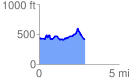
 2.866443 mi
 435.09 ft
 459.11 ft
 -24.01 ft
 3.03 %
GPX Downloads: Track Route
![]()
| at: |
Tannehill Ironworks Historical State Park |
show on map
animate
2.866443 mi
435.09 ft
459.11 ft
-24.01 ft
3.03 %