| at: |
Tannehill Ironworks Historical State Park |
Data from Positive Flow
 show on map
 animate
Trail users:


Elevation Profile
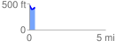
 0.365310 mi
 46.52 ft
 85.57 ft
 -39.05 ft
 4.44 %
GPX Downloads: Track Route
![]()
| at: |
Tannehill Ironworks Historical State Park |
show on map
animate
0.365310 mi
46.52 ft
85.57 ft
-39.05 ft
4.44 %