| at: |
Tannehill Ironworks Historical State Park |
Data from Positive Flow
 show on map
 animate
Trail users:


Elevation Profile
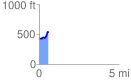
 0.590730 mi
 139.57 ft
 36.60 ft
 102.98 ft
 4.47 %
GPX Downloads: Track Route
![]()
| at: |
Tannehill Ironworks Historical State Park |
show on map
animate
0.590730 mi
139.57 ft
36.60 ft
102.98 ft
4.47 %