| at: |
North Mills River Recreation Area |
Data from Positive Flow
 show on map
 animate
Trail users:


Elevation Profile
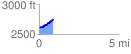
 0.883452 mi
 182.38 ft
 31.69 ft
 150.69 ft
 3.91 %
GPX Downloads: Track Route
![]()
| at: |
North Mills River Recreation Area |
show on map
animate
0.883452 mi
182.38 ft
31.69 ft
150.69 ft
3.91 %