| at: |
North Mills River Recreation Area |
Data from Positive Flow
 show on map
 animate
Trail users:


Elevation Profile
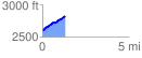
 1.300047 mi
 258.30 ft
 27.20 ft
 231.11 ft
 3.76 %
GPX Downloads: Track Route
![]()
| at: |
North Mills River Recreation Area |
show on map
animate
1.300047 mi
258.30 ft
27.20 ft
231.11 ft
3.76 %