| at: |
Fish Hatchery Area |
Data from Positive Flow
 show on map
 animate
Trail users:


Elevation Profile
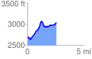
 2.613020 mi
 696.00 ft
 295.68 ft
 400.32 ft
 5.04 %
GPX Downloads: Track Route
![]()
| at: |
Fish Hatchery Area |
show on map
animate
2.613020 mi
696.00 ft
295.68 ft
400.32 ft
5.04 %