| at: |
Greensboro Watershed Trails |
Data from Positive Flow
 show on map
 animate
Trail users:


Elevation Profile
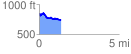
 1.359835 mi
 119.87 ft
 214.75 ft
 -94.88 ft
 2.99 %
GPX Downloads: Track Route
Trailheads:
 Bur Mil Park Big Loop Lot
![]()
| at: |
Greensboro Watershed Trails |
show on map
animate
1.359835 mi
119.87 ft
214.75 ft
-94.88 ft
2.99 %
Bur Mil Park Big Loop Lot