| at: |
Coleman River Scenic Area Trans North Georgia |
Data from David Muse
 show on map
 animate
Trail users:


Elevation Profile
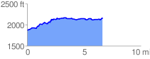
 6.674397 mi
 601.08 ft
 292.18 ft
 308.90 ft
 1.71 %
GPX Downloads: Track Route
![]()
| at: |
Coleman River Scenic Area Trans North Georgia |
show on map
animate
6.674397 mi
601.08 ft
292.18 ft
308.90 ft
1.71 %