| at: |
Chilhowee Recreation Area |
Data from Positive Flow
 show on map
 animate
Trail users:


Elevation Profile
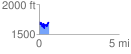
 0.617237 mi
 196.35 ft
 212.87 ft
 -16.53 ft
 6.53 %
GPX Downloads: Track Route
![]()
| at: |
Chilhowee Recreation Area |
show on map
animate
0.617237 mi
196.35 ft
212.87 ft
-16.53 ft
6.53 %