| at: |
Chilhowee Recreation Area |
Data from Positive Flow
 show on map
 animate
Trail users:


Elevation Profile
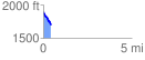
 0.441537 mi
 2.32 ft
 209.64 ft
 -207.32 ft
 8.99 %
GPX Downloads: Track Route
![]()
| at: |
Chilhowee Recreation Area |
show on map
animate
0.441537 mi
2.32 ft
209.64 ft
-207.32 ft
8.99 %