|
| at: |
Warwoman WMA |
Data from USFS GIS
 show on map
 animate
Trail users:


Elevation Profile
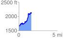
 1.647668 mi
 655.52 ft
 190.44 ft
 465.08 ft
 7.53 %
GPX Downloads: Track Route
![]()
|
| at: |
Warwoman WMA |
show on map
animate
1.647668 mi
655.52 ft
190.44 ft
465.08 ft
7.53 %