|
| at: |
Warwoman WMA |
Data from David Muse
 show on map
 animate
Trail users:


Elevation Profile
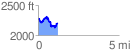
 1.233540 mi
 274.81 ft
 357.00 ft
 -82.19 ft
 5.48 %
GPX Downloads: Track Route
![]()
|
| at: |
Warwoman WMA |
show on map
animate
1.233540 mi
274.81 ft
357.00 ft
-82.19 ft
5.48 %