|
| at: |
LBJ National Grassland |
Data from USFS GIS
 show on map
 animate
Trail users:


Elevation Profile
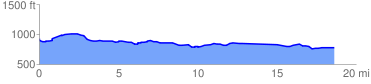
 18.898258 mi
 708.26 ft
 857.65 ft
 -149.39 ft
 0.86 %
GPX Downloads: Track Route
![]()
|
| at: |
LBJ National Grassland |
show on map
animate
18.898258 mi
708.26 ft
857.65 ft
-149.39 ft
0.86 %