| at: |
LBJ National Grassland |
Data from USFS GIS
 show on map
 animate
Trail users:


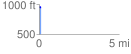
Elevation Profile
 0.142874 mi
 1.64 ft
 15.57 ft
 -13.93 ft
 2.06 %
GPX Downloads: Track Route
![]()
| at: |
LBJ National Grassland |
show on map
animate
0.142874 mi
1.64 ft
15.57 ft
-13.93 ft
2.06 %