| at: |
LBJ National Grassland |
Data from USFS GIS
 show on map
 animate
Trail users:


Elevation Profile
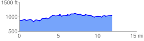
 12.190617 mi
 878.95 ft
 719.47 ft
 159.48 ft
 1.37 %
GPX Downloads: Track Route
![]()
| at: |
LBJ National Grassland |
show on map
animate
12.190617 mi
878.95 ft
719.47 ft
159.48 ft
1.37 %