|
| at: |
LBJ National Grassland |
Data from USFS GIS
 show on map
 animate
Trail users:


Elevation Profile
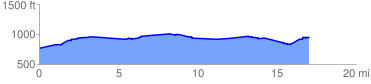
 17.554737 mi
 591.11 ft
 389.66 ft
 201.44 ft
 0.64 %
GPX Downloads: Track Route
![]()
|
| at: |
LBJ National Grassland |
show on map
animate
17.554737 mi
591.11 ft
389.66 ft
201.44 ft
0.64 %