| at: |
LBJ National Grassland |
Data from USFS GIS
 show on map
 animate
Trail users:


Elevation Profile
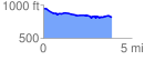
 3.910462 mi
 134.08 ft
 269.48 ft
 -135.40 ft
 1.31 %
GPX Downloads: Track Route
![]()
| at: |
LBJ National Grassland |
show on map
animate
3.910462 mi
134.08 ft
269.48 ft
-135.40 ft
1.31 %