|
| at: |
LBJ National Grassland |
Data from USFS GIS
 show on map
 animate
Trail users:


Elevation Profile
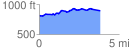
 3.808634 mi
 265.13 ft
 174.57 ft
 90.56 ft
 1.32 %
GPX Downloads: Track Route
![]()
|
| at: |
LBJ National Grassland |
show on map
animate
3.808634 mi
265.13 ft
174.57 ft
90.56 ft
1.32 %