| at: |
LBJ National Grassland |
Data from USFS GIS
 show on map
 animate
Trail users:


Elevation Profile
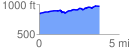
 3.767467 mi
 261.11 ft
 130.09 ft
 131.01 ft
 1.31 %
GPX Downloads: Track Route
![]()
| at: |
LBJ National Grassland |
show on map
animate
3.767467 mi
261.11 ft
130.09 ft
131.01 ft
1.31 %