| at: |
LBJ National Grassland |
Data from USFS GIS
 show on map
 animate
Trail users:


Elevation Profile
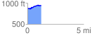
 1.211419 mi
 93.64 ft
 26.63 ft
 67.01 ft
 1.46 %
GPX Downloads: Track Route
![]()
| at: |
LBJ National Grassland |
show on map
animate
1.211419 mi
93.64 ft
26.63 ft
67.01 ft
1.46 %