| at: |
LBJ National Grassland |
Data from USFS GIS
 show on map
 animate
Trail users:


Elevation Profile
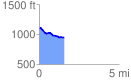
 1.557356 mi
 49.91 ft
 195.04 ft
 -145.13 ft
 2.37 %
GPX Downloads: Track Route
![]()
| at: |
LBJ National Grassland |
show on map
animate
1.557356 mi
49.91 ft
195.04 ft
-145.13 ft
2.37 %