| at: |
LBJ National Grassland |
Data from USFS GIS
 show on map
 animate
Trail users:


Elevation Profile
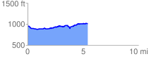
 5.425946 mi
 360.94 ft
 312.69 ft
 48.24 ft
 1.26 %
GPX Downloads: Track Route
![]()
| at: |
LBJ National Grassland |
show on map
animate
5.425946 mi
360.94 ft
312.69 ft
48.24 ft
1.26 %