| at: |
Caddo National Grassland Near Bonham |
Data from USFS GIS
 show on map
 animate
Trail users:


Elevation Profile
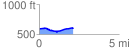
 2.122540 mi
 88.79 ft
 74.22 ft
 14.57 ft
 0.79 %
GPX Downloads: Track Route
![]()
| at: |
Caddo National Grassland Near Bonham |
show on map
animate
2.122540 mi
88.79 ft
74.22 ft
14.57 ft
0.79 %