| at: |
Caddo National Grassland Near Bonham |
Data from USFS GIS
 show on map
 animate
Trail users:


Elevation Profile
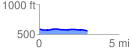
 3.013252 mi
 36.76 ft
 67.97 ft
 -31.21 ft
 0.43 %
GPX Downloads: Track Route
![]()
| at: |
Caddo National Grassland Near Bonham |
show on map
animate
3.013252 mi
36.76 ft
67.97 ft
-31.21 ft
0.43 %