| at: |
Caddo National Grassland Near Ladonia |
Data from USFS GIS
 show on map
 animate
Trail users:


Elevation Profile
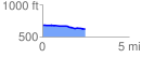
 2.456150 mi
 17.83 ft
 71.92 ft
 -54.09 ft
 0.55 %
GPX Downloads: Track Route
![]()
| at: |
Caddo National Grassland Near Ladonia |
show on map
animate
2.456150 mi
17.83 ft
71.92 ft
-54.09 ft
0.55 %