| at: |
Caddo National Grassland Near Bonham |
Data from USFS GIS
 show on map
 animate
Trail users:


Elevation Profile
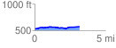
 3.194888 mi
 101.60 ft
 56.05 ft
 45.55 ft
 0.60 %
GPX Downloads: Track Route
![]()
| at: |
Caddo National Grassland Near Bonham |
show on map
animate
3.194888 mi
101.60 ft
56.05 ft
45.55 ft
0.60 %