| at: |
Caddo National Grassland Near Bonham |
Data from USFS GIS
 show on map
 animate
Trail users:


Elevation Profile
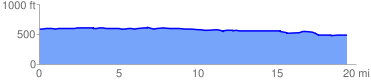
 19.557885 mi
 210.59 ft
 308.59 ft
 -98.00 ft
 0.30 %
GPX Downloads: Track Route
![]()
| at: |
Caddo National Grassland Near Bonham |
show on map
animate
19.557885 mi
210.59 ft
308.59 ft
-98.00 ft
0.30 %