| at: |
Caddo National Grassland Near Bonham |
Data from USFS GIS
 show on map
 animate
Trail users:

Elevation Profile
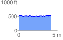
 4.209759 mi
 257.71 ft
 258.59 ft
 -0.88 ft
 1.16 %
GPX Downloads: Track Route
![]()
| at: |
Caddo National Grassland Near Bonham |
show on map
animate
4.209759 mi
257.71 ft
258.59 ft
-0.88 ft
1.16 %