| at: |
Caddo National Grassland Near Bonham |
Data from USFS GIS
 show on map
 animate
Trail users:


Elevation Profile
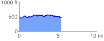
 5.492504 mi
 494.52 ft
 500.20 ft
 -5.68 ft
 1.72 %
GPX Downloads: Track Route
![]()
| at: |
Caddo National Grassland Near Bonham |
show on map
animate
5.492504 mi
494.52 ft
500.20 ft
-5.68 ft
1.72 %