| at: |
Angelina National Forest |
Data from USFS GIS
 show on map
 animate
Trail users:


Elevation Profile
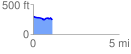
 1.130845 mi
 53.54 ft
 93.85 ft
 -40.31 ft
 1.57 %
GPX Downloads: Track Route
![]()
| at: |
Angelina National Forest |
show on map
animate
1.130845 mi
53.54 ft
93.85 ft
-40.31 ft
1.57 %