|
| at: |
Angelina National Forest |
Data from USFS GIS
 show on map
 animate
Trail users:


Elevation Profile
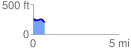
 0.695719 mi
 34.97 ft
 99.07 ft
 -64.10 ft
 2.70 %
GPX Downloads: Track Route
![]()
|
| at: |
Angelina National Forest |
show on map
animate
0.695719 mi
34.97 ft
99.07 ft
-64.10 ft
2.70 %