| at: |
Angelina National Forest |
Data from USFS GIS
 show on map
 animate
Trail users:


Elevation Profile
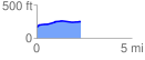
 2.307895 mi
 107.38 ft
 21.80 ft
 85.59 ft
 0.88 %
GPX Downloads: Track Route
![]()
| at: |
Angelina National Forest |
show on map
animate
2.307895 mi
107.38 ft
21.80 ft
85.59 ft
0.88 %