|
| at: |
Angelina National Forest |
Data from USFS GIS
 show on map
 animate
Trail users:


Elevation Profile
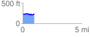
 0.982397 mi
 54.95 ft
 47.85 ft
 7.10 ft
 1.06 %
GPX Downloads: Track Route
![]()
|
| at: |
Angelina National Forest |
show on map
animate
0.982397 mi
54.95 ft
47.85 ft
7.10 ft
1.06 %