|
| at: |
Angelina National Forest |
Data from USFS GIS
 show on map
 animate
Trail users:


Elevation Profile
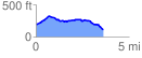
 3.668238 mi
 237.16 ft
 324.76 ft
 -87.60 ft
 1.68 %
GPX Downloads: Track Route
![]()
|
| at: |
Angelina National Forest |
show on map
animate
3.668238 mi
237.16 ft
324.76 ft
-87.60 ft
1.68 %