|
| at: |
Angelina National Forest |
Data from USFS GIS
 show on map
 animate
Trail users:


Elevation Profile
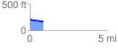
 0.867287 mi
 7.99 ft
 54.71 ft
 -46.72 ft
 1.19 %
GPX Downloads: Track Route
![]()
|
| at: |
Angelina National Forest |
show on map
animate
0.867287 mi
7.99 ft
54.71 ft
-46.72 ft
1.19 %