|
| at: |
Angelina National Forest |
Data from USFS GIS
 show on map
 animate
Trail users:


Elevation Profile
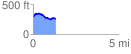
 1.318741 mi
 98.93 ft
 152.36 ft
 -53.43 ft
 2.19 %
GPX Downloads: Track Route
![]()
|
| at: |
Angelina National Forest |
show on map
animate
1.318741 mi
98.93 ft
152.36 ft
-53.43 ft
2.19 %