|
| at: |
Angelina National Forest |
Data from USFS GIS
 show on map
 animate
Trail users:


Elevation Profile
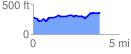
 3.893818 mi
 322.54 ft
 258.52 ft
 64.02 ft
 1.57 %
GPX Downloads: Track Route
![]()
|
| at: |
Angelina National Forest |
show on map
animate
3.893818 mi
322.54 ft
258.52 ft
64.02 ft
1.57 %