|
| at: |
Angelina National Forest |
Data from USFS GIS
 show on map
 animate
Trail users:


Elevation Profile
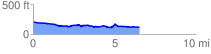
 6.603379 mi
 201.51 ft
 298.30 ft
 -96.79 ft
 0.86 %
GPX Downloads: Track Route
![]()
|
| at: |
Angelina National Forest |
show on map
animate
6.603379 mi
201.51 ft
298.30 ft
-96.79 ft
0.86 %