| at: |
Angelina National Forest |
Data from USFS GIS
 show on map
 animate
Trail users:


Elevation Profile
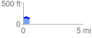
 0.517045 mi
 44.68 ft
 53.16 ft
 -8.48 ft
 1.95 %
GPX Downloads: Track Route
![]()
| at: |
Angelina National Forest |
show on map
animate
0.517045 mi
44.68 ft
53.16 ft
-8.48 ft
1.95 %