| at: |
Angelina National Forest |
Data from USFS GIS
 show on map
 animate
Trail users:


Elevation Profile
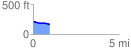
 0.983093 mi
 6.38 ft
 44.05 ft
 -37.67 ft
 0.85 %
GPX Downloads: Track Route
![]()
| at: |
Angelina National Forest |
show on map
animate
0.983093 mi
6.38 ft
44.05 ft
-37.67 ft
0.85 %