| at: |
Angelina National Forest |
Data from USFS GIS
 show on map
 animate
Trail users:


Elevation Profile
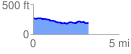
 3.247438 mi
 107.36 ft
 183.07 ft
 -75.71 ft
 1.07 %
GPX Downloads: Track Route
![]()
| at: |
Angelina National Forest |
show on map
animate
3.247438 mi
107.36 ft
183.07 ft
-75.71 ft
1.07 %