| at: |
Angelina National Forest |
Data from USFS GIS
 show on map
 animate
Trail users:


Elevation Profile
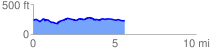
 5.656278 mi
 287.84 ft
 309.97 ft
 -22.13 ft
 1.04 %
GPX Downloads: Track Route
![]()
| at: |
Angelina National Forest |
show on map
animate
5.656278 mi
287.84 ft
309.97 ft
-22.13 ft
1.04 %