| at: |
Angelina National Forest |
Data from USFS GIS
 show on map
 animate
Trail users:


Elevation Profile
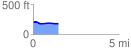
 1.489754 mi
 26.79 ft
 45.40 ft
 -18.62 ft
 0.58 %
GPX Downloads: Track Route
![]()
| at: |
Angelina National Forest |
show on map
animate
1.489754 mi
26.79 ft
45.40 ft
-18.62 ft
0.58 %